
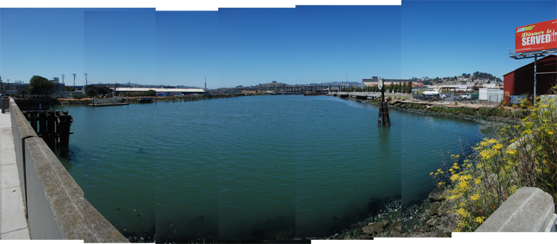
ISLAIS CREEK is a channel providing an outlet for the largest watershed in San Francisco. The channel is surrounded by several small parks including Islais Landing on the southern bank and Tulare Park and the Islais Creek Promenade on the north.
A place for active recreation, Islais Landing has a boat launch stewarded by Kayaks Unlimited and Friends of Islais Creek, while the promenade has become a hot spot for skateboarding. Proposals for the area include connecting these parks with a loop trail around the channel, wetlands and continued environmental remediation, a new SFMTA bus facility, and new uses for the surrounding properties that are more compatible with recreation. For more detail, see Sara Jensen Carr’s report Imagining Islais Creek as well as Eustacia Brossart’s proposal for 3rd & Cargo.
HISTORY
The word Islais comes from the Ohlone name for the wild cherry plant, the Hollyleaf Cherry (Prunus ilicifolia), that once grew along the banks of the creek. The Muwekma Ohlone tribe lived in this area and would forage for mussels, shrimp and clams along the coast and river inlets. When Spanish explorers arrived in San Francisco, they appropriated a version of this name "Is Lay Is" for the creek that was a critical agricultural source for the valley.[1]
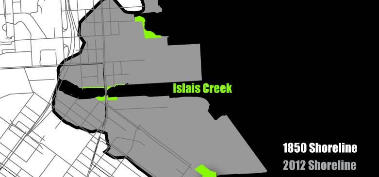
Diagram of filled land around Islais Creek
Islais Creek once flowed through San Francisco from Glen Canyon Park to the bay. The creek has been culverted and flows underground through pipes beneath city streets. What is visible now is a channel conveying this water out to the bay. Until the late 1800's it is estimated that Islais Creek provided up to 85% of the city's drinking water and its rich banks became home to farms and gardens of Portuguese, Italian, and Irish immigrants in what is now Bayview. [2]

Image: Islais Creek emerging from Glen Canyon, 1890's, Greg Gaar Collection, courtesy of FoundSF.org
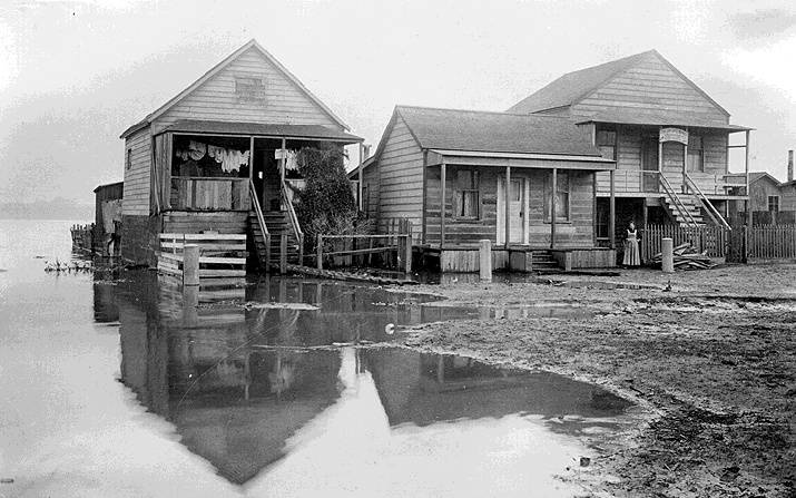
Image: An Italian Shoemaker has his family home and shop at the edge of the Islais Creek swamp, c. 1900, Greg Gaar Collection, courtesy of FoundSF.org
The rapid growth in population created by the Gold Rush and subsequent industrialization changed the landscape of Islais Creek drastically. The tidelands around the creek became the home to "Butchertown" as meat packing industries were forced to move from downtown and took advantage of cheap prices and relative isolation along the banks of Islais Creek. The area became the center of the city’s meatpacking, shipping, and processing industries and operated until 1971 when the final slaughterhouse closed.[3] These factories used the creek as a sewer, dumping waste directly into the water to be carried away by the tides. In part to address the sanitation problems created by these actions, city officials forced the creek underground into concrete boxes and culverts in the 1930’s.[4] For more on the history of Butchertown see Sparkle Tack, FoundSF.org, and Sara's 2008 Report Imagining Islais Creek.

Image: Butchertown in 1921, San Francisco History Center, San Francisco Public Library, from FoundSF.org
After the meat packing and processing industries went into decline, they were replaced by auto wrecking and scrap yards as well as other industrial uses. The construction of Highways 101 and 280 further disconnected the creek from the surrounding neighborhoods and Islais Creek came into greater disrepair.
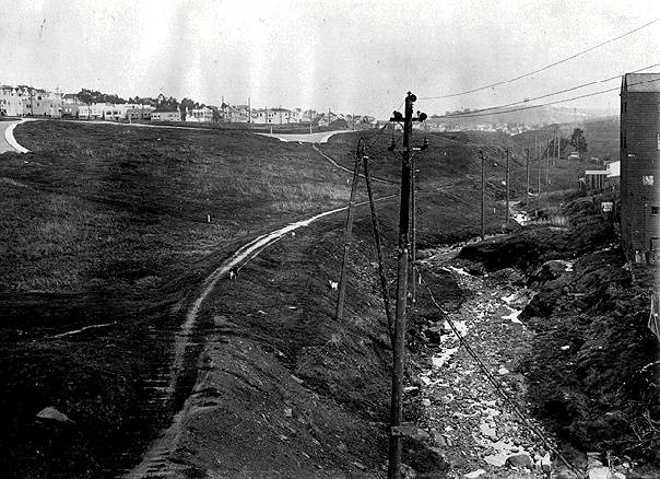
Image: Islais Creek, 1910, Greg Gaar Collection, courtesy of FoundSF.org
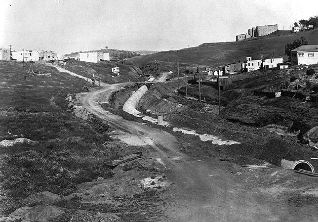
Image: Islais Creek, 1930, Greg Gaar Collection, courtesy of FoundSF.org; Note the building at upper right, which reappears in the following photo
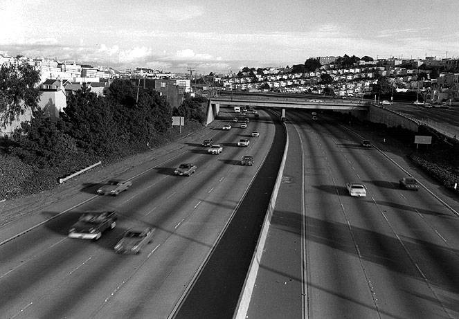
Image: Islais Creek under 280, 1980's, Greg Gaar Collection, courtesy of FoundSF.org
Along the banks of the channel sits the Copra Crane, a remnant from the Cargill Mill at Pier 84 that operated from the 1940's till the 1970's. The mill processed copra, dried coconut meat, from the Phillipines, turning it into coconut oil and other industrial products. The crane is currently being restored and will serve as a labor monument recognizing the longshoremen and workers along the entirety of the southeast waterfront.[5] For more on the copra trade, see FoundSF.org and Herb Mills report on the Copra Dock.
Image: Copra Crane, 2008, Sara Jensen Carr
Since 1984, the Friends of Islais Creek group has formed and taken an active role in stewarding the channel and advocating for its regeneration. They have worked with MUNI, the Department of Public Works, Caltrans, the Public Utilities Commission, and the Port of San Francisco to advocate for the creation of several of the parks located along the channel.[6] While still more work is to be done, growing numbers of wildlife have been returning to the area where brown pelicans and other shorebirds can be seen diving for food.
- REFERENCES
- Sara Jensen Carr, "Imagining Islais Creek," 2008
- Ibid.
- Connor Casey, "Butchertown's Beginnings" http://foundsf.org/index.php?title=Butchertown's_Beginnings
- Sara Jensen Carr, "Imagining Islais Creek," 2008
- Herb Mills, "Article 30 The San Francisco Waterfront: The Copra Dock," http://www.ilwu10hmills.com/articles/pdfs/Article%2030.pdf
- Sara Jensen Carr, "Imagining Islais Creek," 2008
- IMAGE CREDITS
- Image: Islais Creek emerging from Glen Canyon, 1890's, Greg Gaar Collection, from http://www.foundsf.org/images/6/69/Islais-creek.jpg in "Islais Creek Remembered" http://foundsf.org/index.php?title=Islais_Creek_Remembered
- Image: An Italian Shoemaker has his family home and shop at the edge of the Islais Creek swamp, c. 1900, Greg Gaar Collection, from http://foundsf.org/images/b/bb/Bayvwhp%24italian-shoe-mkt-on-islais-ck-.jpg in "Shopping in the Bayview, 1920s" http://www.foundsf.org/index.php?title=Italian_Shoe_Market
- Image: Butchertown in 1921, San Francisco History Center, San Francisco Public Library, http://www.foundsf.org/images/d/da/Cattle_in_Butchertown_jan_11_1921_AAB-6727.jpg in "Butchertown's Beginnings" http://foundsf.org/index.php?title=Butchertown's_Beginnings
- Image: Islais Creek, 1910, Greg Gaar Collection from http://foundsf.org/images/4/48/Excelvis%24alemany-boulevard-1910.jpg in "Islais Creek Covered" http://foundsf.org/index.php?title=Islais_Creek_Covered
- Image: Islais Creek, 1930, Greg Gaar Collection from http://foundsf.org/images/e/e1/Alemany_islais-creek-1930.jpg in "Islais Creek Covered" http://foundsf.org/index.php?title=Islais_Creek_Covered
- Image: Islais Creek under 280, 1980's, Greg Gaar Collection from http://foundsf.org/images/0/04/Alemany_I-280_islais-creek-1980s.jpg in "Islais Creek Covered" http://foundsf.org/index.php?title=Islais_Creek_Covered
- Image: Copra Crane, 2008, Sara Jensen Carr, "Imagining Islais Creek"
AMENITIES


ADDITIONAL IMAGES