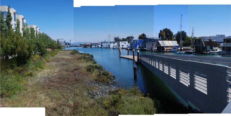
MISSION CREEK is a channel running parallel to Berry street along the north of Mission Bay. The park along the northern side of Mission Creek runs between Fourth St and Seventh St as a paved prominade with a viewing platform at Fifth St. The prominade is lined with benches and trees and features a public boat launch for non-motorized boats. At the end of the park under 280 are basketball, sand volleyball and a tennis court as well as an off leash dog area.
The southern park is just over three acres and has two different characters along its length. The eastern end of the park has rolling turf, a small outdoor amphitheatre and a pavilion. Public restrooms, water and seating are available near this building. The western end of the park is maintained by the community of houseboaters who live in the creek as a native plant garden which provides habitat for butterflies and many wetland species that live along the bay. This community has been instrumental in the rehabilitation of the channel banks as the Mission Bay development has proceeded. For more information visit the Mission Bay Park System site.
AMENITIES
HISTORY

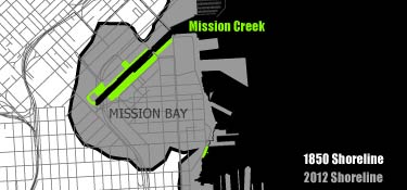
Diagram of filled land around Mission Creek Park
Once an actual bay, the area around Mission Creek was filled during the 19th century. Mission Creek used to flow inland deep into the Mission District but was forced underground into pipes as the city expanded.

1852 U.S. Coastal Survey map of San Francisco's Mission Bay and surrounding areas, courtesy of FoundSF.org
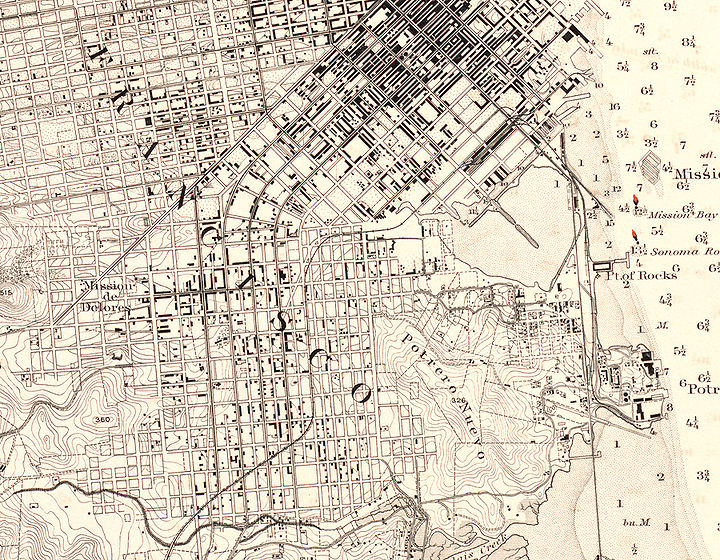
The marshlands in the bay were first closed off in 1865 by the Long Bridge, a wooden causway that extended Third Street from downtown toward Potrero Point and the Central Waterfront.[1] Shortly thereafter, the passing of the California’s Tidelands Act of 1868 set off a land grab in Mission Bay. The governor of California appointed a Board of Tidelands Commission to survey and auction off all land up to 24 feet past the lowest tides. Another provision of the Act stipulated that any improved tidelands in possession prior to January 1st of that year would be offered to the owner to purchase first before the public auction. Squatters, or settlers, interpreted the "improved" condition quite liberally, and the Commission was mired in multiple claims and legal suits.[2]

1889 U.S. Coastal Survey Map, Christopher Richard, Oakland Museum of California, courtesy of FoundSF.org
The bay was filled using all kinds of debris, from rotting piers and grounded ships to garbage from the densely populated south-of-Market district brought by wagon to be dumped daily. The pollution in Mission Bay from industrial activity and dumping became so great that the water was "sickening to smell and deadly to fall into."[3] The channel to the south of Townsend was kept open as Channel St to serve the industries in SOMA and was a bustling port area through the 1950's. Mission Bay was home to railyards and warehouses of the Southern Pacific Railroad, until the 1990's when their real estate division, Catellus, received approval from the city to redevelop the site. The Mission Creek Conservancy first formed around this time in the mide 1980's to advocate for the community about the proposed development.

Aerial view of Mission Bay in early 1980s when it was still railroad land with warehouses and industrial facilities, Santa Fe Pacific Railroad, courtesy of FoundSF.org
For more information on the history of Mission Bay, see Vanished Waters, excerpts of which can be seen at FoundSF.org.
Mission Bay will be home to a new UCSF medical facility and research campus as well as new commercial, residential developments. For more details about the project, see the Mission Bay Project site.
- REFERENCES
- John Borg, "The Story of Dogpatch," http://pier70sf.org/dogpatch/dogpatch_history.htm
- Nancy J. Olmsted, "Mission Bay Tidelands Controversy, 1868-1879," excerpt from Vanished Waters found at http://foundsf.org/index.php?title=Mission_Bay_Tidelands_Controversy,_1868-1879
- Ibid.
- IMAGE CREDITS
- Image: 1852 U.S. Coastal Survey map of San Francisco's Mission Bay and surrounding areas, FoundSF.org, from http://www.foundsf.org/images/b/b4/1852-US-Coast-Survey-map-of-Mission-Bay-w-Mission-Plank-Road.jpg in "Mission Plank Road" http://www.foundsf.org/index.php?title=Mission_Plank_Road
- Image: 1889 U.S. Coastal Survey Map, Christopher Richard, Oakland Museum of California, from http://foundsf.org/images/thumb/d/db/1889-coastal-survey-map-mission-bay-detail.jpg/720px-1889-coastal-survey-map-mission-bay-detail.jpg in "Mission Bay Tidelands Controversy, 1868-1879" http://foundsf.org/index.php?title=Mission_Bay_Tidelands_Controversy,_1868-1879
- Image: Aerial view of Mission Bay in early 1980s when it was still railroad land with warehouses and industrial facilities, Santa Fe Pacific Railroad, from http://www.foundsf.org/images/b/be/Mission-Bay-bw-looking-north-c-1980s-Santa-Fe-Pacific-RR.jpg in "Mission Bay" http://www.foundsf.org/index.php?title=MISSION_BAY


