
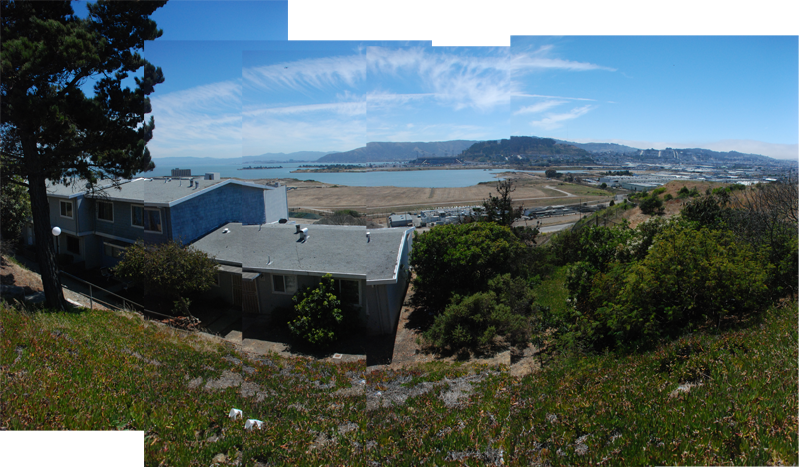
HUNTERS POINT from the corner of Earl St. and La Salle St. offers a view onto the Hunters Point Shipyard, a 963 acre Superfund site formerly operated by the Navy. This location is a stop on a self-guided, toxic 'tour,' a project from Arc Ecology and the San Francisco Department of the Environment, that outlines the hazards present on the Naval Shipyard site. A sign provided at this stop explains the clean up sites on Parcel E2 which are visible from this vantage. This parcel was formerly a landfill for the shipyard, and is one of the most contaminated and controversial areas of the project.
The shipyard was home to many industrial activities as well as early research into radioactive materials and their effects. As there were no regulations governing landfills prior to 1970, toxic materials were disposed of on the site without barriers to keep them from leaching into the groundwater or adjacent bay or for limiting the exposure of nearby communities and workers to them. The contaminants found on the shipyard site are associated with many health and neurological problems, including cancer, liver disease, and asthma.
The remediation method for this parcel is currently being debated, but there are no easy answers. Many in the community favor excavation of the contaminated materials and their removal to a hazardous waste site, as the Shipyard is located adjacent to the water and on fill in a place with seismic activity, both of which may jeopardize other containment methods. The community has hired Arc Ecology to provide them with on-going technical support about the cleanup process. Arc is currently perusing an independent technical review of the Navy's work on Parcel E2.
The shipyard site has the potential to benefit the Hunters Point Bayview neighborhood which has faced high levels of unemployment since the shipyards closed in addition to discrimination, isolation, and the effects of a highly compromised environment. Proposals for the site include the creation of over 10,000 new housing units, 200 acres of parks and open space, clean technology research space, and commercial and retail development.
Hear more about the shipyards and the Bayview community from Olin and Doris:
Listen to Hunters Point Part IListen to Hunters Point Part II
Click to play or Right click/Command click to play in another tab
HISTORY
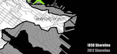
Diagram of filled land around Hunters Point
Hunters Point became the site of the first dry dock on the Pacific coast in 1869, built by the Hunters family for which the area is named. [1] Shipbuilding became a major industry in the area, with diverse operations from the scale of large war ships down to small private boat repair, shipping and shrimping. The Navy purchased the dry dock site and surrounding areas in 1939 and was responsible for filling much of the area as they expanded their operations.[2] This led to the destruction of the shrimping industry as well as many areas of beach, wetland and shoreline that had been important recreation spaces for the community.
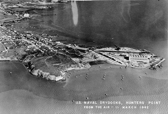
Image: Beginning of Hunters Point Yard's Growth, 1942, San Francisco History Center, San Francisco Public Library, courtesy of FoundSF.org
The Shipyards were at their peak during the 1940's, building warships used in WWII and housing the Naval Radiological Defense Laboratory which conducted early research into radioactive materials from 1946-1969.[3] During this time, many African-Americans moved to the area from the South as they found work at the shipyard and the population in the Bayview boomed. Production began to slow after the war and many of these workers were laid off. This decline was mirrored in other industries in the area, and unemployment reached almost 50% within the African-American community.[4] The Navy closed the shipyard in 1974 and it sat vacant for two years before they leased it to a private ship repair company, Triple A.
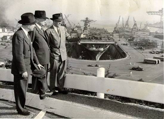
Hunter's Point Naval Shipyard, Drydock 4, 1952, San Francisco History Center, San Francisco Public Library, courtest of FoundSF.org
The first environmental investigation into the shipyard occured in 1986 leading to the closure of Triple A's operations. In 1989 the EPA placed the Hunters Point Naval Shipyard on the National Priorities List, a list of the most polluted sites in the country.[5] The Navy is responsible for cleaning up the site and will transfer the property to the City and County of San Francisco to be redeveloped once it meets the standards for the planned reuse.[6]
To expedite the process, the site has been divided into parcels, lettered A – F, for more targeted investigation and remediation.[6] Parcel A was the least contaminated area and was returned to the city in 2004, but the redevelopment process has moved along slowly to the frustration of many in the community. Parcel E is one of the most contaminated sites, and it was further subdivided into Parcel E and Parcel E2, the latter being the location of the former landfill. The landfill caught fire in 2000 and it spread underground where it burned for several weeks. The Navy informed neither the EPA nor neighboring residents about the fire upon its discovery.[7]

Map of the Hunters Point Shipyard, 2004, Community Window on the Hunters Point Shipyard
The Navy partially capped the landfill in 2001 to cut off the supply of oxygen and stop the fire. It maintains monitoring wells at the EPA's direction to test for methane gas and has installed a gas extraction system after it was discovered that the gas was spreading underground to adjacent areas.[8]
The site contains many heavy metals, toxic organic compounds and low level radiation, varying in magnitude over the parcels. In addition to the Naval Radiological Defense Laboratory, the shipyard decontaminated and repaired nuclear powered submarines and ships. It consolidated radioactive waste from other Naval sites, disposing of much of it 15 miles off the coast in the Pacific Ocean near the Farralone Islands, but some of it on site. [9]
- REFERENCES
- Arc Ecology, et al. From Pollution to Parkland: Alternatives for a Waterfront Park at Hunters Point Shipyard, 2006.
- Ibid.
- Ibid.
- Ibid.
- Environmental Protection Agency, "Hunters Point Shipyard," http://yosemite.epa.gov/r9/sfund/r9sfdocw.nsf/vwsoalphabetic/hunters+point+naval+shipyard?opendocument
- Arc Ecology, "Project: Hunters Point Shipyard," http://www.arcecology.org/HuntersPoint.shtml
- Environmental Protection Agency, "Hunters Point Shipyard," http://yosemite.epa.gov/r9/sfund/r9sfdocw.nsf/vwsoalphabetic/hunters+point+naval+shipyard?opendocument
- Ibid.
- Community Window on the Hunters Point Shipyard, "Radiation at the Hunters Point Shipyard," http://www.communitywindowontheshipyard.org/toxics_radiation/radiation.htm
- IMAGE CREDITS
- Image: Beginning of Hunters Point Yard's Growth, 1942, San Francisco History Center, San Francisco Public Library, from http://foundsf.org/images/d/d9/March_11_1942_aerial_of_HP_Naval_drydocks_AAB-8939.jpg in "Hunter's[sic] Point Naval Shipyard" http://foundsf.org/index.php?title=Hunter's_Point_Naval_Shipyard
- Image: Hunter's Point Naval Shipyard, Drydock 4, 1952, San Francisco History Center, San Francisco Public Library, from http://foundsf.org/images/2/28/Drydock_4_1952_2265110_1b61a8d848_o.jpg in "Hunter's[sic] Point Naval Shipyard" http://foundsf.org/index.php?title=Hunter's_Point_Naval_Shipyard
- Image: Map of the Hunters Point Shipyard, 2004, Community Window on the Hunters Point Shipyard, from http://www.communitywindowontheshipyard.org/images/HPS-BldgsRds-Sept2004-web-big.jpg in "Map of the Hunters Point Shipyard" http://www.communitywindowontheshipyard.org/cleanupguide/map_main.htm
AMENITIES
None.ADDITIONAL IMAGES